Enough of Hygge - 7 - Gentofte and Dyrehaven

Dyrehaven.
Bernstorff Palace.
Gentofte Lake.
Introduction
Gentofte is the neighbouring commune to the north of Copenhagen containing the borough of Hellerup. It is posh. There is a tacit rule in Denmark, known as Jante's Law, that declares one should not display signs of ostentatious wealth. Jante was clearly not based around the people of Gentofte.
The Dyrehaven (The Deer Park) is an old royal hunting estate - a vast area of woods and meadows, which is indeed a haven for wildlife. In size and character it is similar to Richmond Park in London.
The following tour blends the raw sea with the groomed parks and the genteel suburbs.
Note: The map (above) and photographs can be enlarged by clicking on them (opens in a new browser tab). On the map north is 90° clockwise, i.e. at 03:00 on an old school analogue clock.
![]() tart:
tart:
Start at the south-eastern side of Østerport Station on Folke Bernadottes Allé, facing north-east, by the trees of Kastellet (GPS 55.69159 12.58851).
![]() Orient yourself north-eastwards with the station to your left and the trees
of Kastellet to your right.
Start pedalling along Folke Bernadottes Allé and continue straight over the
traffic lights at Indiakaj. Fifty meters further on there is a break in the
fence next to a two-storey brick office
(GPS 55.69591 12.59409).
Go through the car-park to emerge onto Dampfærgevej.
This has a mix of old harbour buildings and newer developments. Continue
to the end where Dampfærgevej curves to the left.
Here is the dock for the Copenhagen to Oslo ferry. Follow the road round
to the left and at the main road turn right
(Kalkbrænderihavnsgade).
Orient yourself north-eastwards with the station to your left and the trees
of Kastellet to your right.
Start pedalling along Folke Bernadottes Allé and continue straight over the
traffic lights at Indiakaj. Fifty meters further on there is a break in the
fence next to a two-storey brick office
(GPS 55.69591 12.59409).
Go through the car-park to emerge onto Dampfærgevej.
This has a mix of old harbour buildings and newer developments. Continue
to the end where Dampfærgevej curves to the left.
Here is the dock for the Copenhagen to Oslo ferry. Follow the road round
to the left and at the main road turn right
(Kalkbrænderihavnsgade).
Nordhavn:
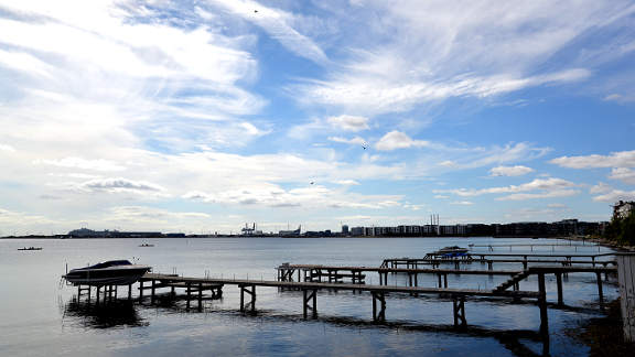
The route passes Nordhavn (North harbour) basin where new apartments line the shore and people swim and sun themselves in fine weather. Behind the harbourside blocks Nordhavn stretches over 2km out into the Øresund - a mishmash of offices, industry and reclaimed land. The largest ocean cruise liners also tie up here - a rather bleak introduction to the delights of Copenhagen.
Continue along the main road with the raised railway to your left. After some modern office blocks the view opens up over a small marina with the imposing brick clad Svanemøllevæerket power station beyond.
![]() 1
Completed in 1953 in a functionalistic style
Svanemøllevæerket has undergone a number of
changes, from coal burning to gas and oil, and from electricity supply to
hot water. When its power supply days are over ther are plans to convert
it into an industrial museum.
1
Completed in 1953 in a functionalistic style
Svanemøllevæerket has undergone a number of
changes, from coal burning to gas and oil, and from electricity supply to
hot water. When its power supply days are over ther are plans to convert
it into an industrial museum.
To the north of the power station lies the large marina of Svanemøllehavn. Where the main road curves round to the left at some traffic lights the cycle track continues ahead, parallel to the harbour (GPS 55.71604 12.58417).
Tuborg Havn:
The next stretch runs along side the beach of Svanemøllestrand, a pleasant diversion from the busy road so far. After 300m the main road turns away from the coast (GPS 55.71963 12.58269). Turn right here to continue alongside the beach (Srandpromenaden). At the end of this road a cycle track leads on into the newly developed Tuborg harbour area (named after the brewery that used to occupy the site (GPS 55.72154 12.58278). The cycle track snakes through the development to a large roundabout at the end of Dessaus Boulevard (GPS 55.72393 12.58172).
![]() 2
Go straight across the roundabout and head north on
Phillip Heymans Alle. Cross the harbour basin and pass the Experimentarium,
an interactive science and technology museum. Go straight over the next
roundabout. At the next crossroads turn right onto Hans Bekkevolds Alle
(GPS 55.72805 12.57976),
and just before the end, where it changes to cobbles, turn left onto the
marked pedestrian and cycle way
(GPS 55.72831 12.58134).
2
Go straight across the roundabout and head north on
Phillip Heymans Alle. Cross the harbour basin and pass the Experimentarium,
an interactive science and technology museum. Go straight over the next
roundabout. At the next crossroads turn right onto Hans Bekkevolds Alle
(GPS 55.72805 12.57976),
and just before the end, where it changes to cobbles, turn left onto the
marked pedestrian and cycle way
(GPS 55.72831 12.58134).
Hellerup:
The narrow track weaves between flowerbeds until it suddenly deposits you onto Carolinevej, and into one of the desirable districts of Hellerup. Turn left and take the first right onto Tellersvej. At the next junction (Marievej) turn left and then immediately right onto Kodansvej. Take the next left onto Frederikkevej and after 20m take the combined pedestrian and bridleway on the right. This pops you out onto Strandparksvej (GPS 55.73155 12.58007).
Turn right towards the sea and go left around the mini-roundabout to pass alongside the Hellerup yacht harbour. At the end of the harbour turn left and then immediately right, in front of the low stone building, to end up on Onsgårdsvej. Straight across the road is another combined cycle and pedestrian path, take this onto Jomsborgvej (GPS 55.73332 12.57959). Turn right and first left onto Sundvej which leads to Lille Strandvej (GPS 55.73434 12.58060). You will have noticed that all these east/west roads end abruptly at the sea with great views over the Øresund.
We have to turn away from the sea for a while but we will return. Turn left down Lille Strandvej to where it meets the main road through Hellerup (Strandvejen) (GPS 55.73454 12.57495).
A further 400m north a park opens up on the left surrounding the distinctive white mansion of Øregaard museum. And on the right is the tree-lined avenue of Hambros Alle (GPS 55.73825 12.57607).
![]() 3
Hambros Alle is one of the most exclusive addresses in Copenhagen, so turn
right and follow it to its end where there is a fine viewpoint out onto
the Øresund.
To the right can be seen Tuborg Havn, then Nordhavn with the highpoints of
Refshaleøen behind.
Out in the Øresund the defensive island of
Middelgrundsfort comes next. And further left in the far distance is the
coast of Sweden.
3
Hambros Alle is one of the most exclusive addresses in Copenhagen, so turn
right and follow it to its end where there is a fine viewpoint out onto
the Øresund.
To the right can be seen Tuborg Havn, then Nordhavn with the highpoints of
Refshaleøen behind.
Out in the Øresund the defensive island of
Middelgrundsfort comes next. And further left in the far distance is the
coast of Sweden.
When you are rested reverse back down Hambros Alle and turn right, back onto the main road (Strandvejen).
Charlottenlund:
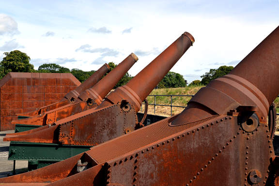
Continue down Strandvejen, past undistinguished apartment blocks, until woods and park appear to the left and right. It soon becomes clear that there is a substantial, moated earthwork emerging from behind the trees. This is Charlottenlund Fort (GPS 55.74810 12.58714).
![]() 4
Originally built as a battery in the 1880's Charlottenlund Fort was
converted to a coastal fort in 1912 with twelve 29cm howitzers which can
still be seen in their original setting.
Today the fort includes a campsite within its grounds - a modern day
Trojan Horse would be a campervan.
Access to the beach and the fort can be gained down the
hedge-lined path just past the moat.
4
Originally built as a battery in the 1880's Charlottenlund Fort was
converted to a coastal fort in 1912 with twelve 29cm howitzers which can
still be seen in their original setting.
Today the fort includes a campsite within its grounds - a modern day
Trojan Horse would be a campervan.
Access to the beach and the fort can be gained down the
hedge-lined path just past the moat.
To the left of the main road is Charlottenlund Forest with its Palace. Once a royal park and palace, the park is now open to the public and the palace is now a conference centre.
Around a gentle curve the track becomes a true coast road with only the seawall between you and the Øresund. The cycle track is wide and fast (presuming a benign headwind), giving a glorious straight 1km ride. In all likelihood any number of Mamils (middle-aged men in lycra) will zip past you on their racing bikes, but hey this is not a race.
The sea briefly disappears behind the Skovshoved marina (GPS 55.76069 12.59904), before re-appearing on the far side in a gentle sweep with Sweden 40km to the east.
Klampenborg:
A further 700m north, where the road arcs to the north-west a platform sticks out into the sea with a huge granite plinth and a statue of a man gazing out to sea - this is Knud Rasmussen - a polar explorer and collector (GPS 55.77187 12.59617). The landward side of the plinth lists all of his major expeditions.
![]() 5
The road curves back north and in 500m you come upon Bellevue beach, the
most popular beach in the Copenhagen area. In the 1930's, after the right
to vacation was set into law, the beach complex was developed with the
architect Arne Jacobsen designing all the trimmings from bathing cabins,
kiosks and lifeguard towers to tickets and staff outfits.
5
The road curves back north and in 500m you come upon Bellevue beach, the
most popular beach in the Copenhagen area. In the 1930's, after the right
to vacation was set into law, the beach complex was developed with the
architect Arne Jacobsen designing all the trimmings from bathing cabins,
kiosks and lifeguard towers to tickets and staff outfits.
The road continues slightly inland with the thatched Yellow Cottage on the right and an 800 year old oak tree (Skovfogedegen) on the left. At the next road junction (Taarbæk Strandvej) follow the cycle track across the road and then where it curves left cross at the lights to continue west alongside Dyrehavevej (GPS 55.78029 12.58929). After just 50m the cycle track departs from the road into the woods on the right - follow this cycle track.
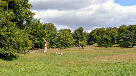
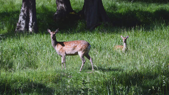
Dyrehaven:
Where the cycle track meets the railway track turn left (GPS 55.78052 12.58731), and pass under the road and up a slight rise to join Peter Lieps Vej at the bridge over the railway (GPS 55.77847 12.58795). Turn right over the railway and 100m further go through the red gate into the Dyrehaven (The Deer Park).
![]() 6
The deer park was laid out in the late 17th century
as a royal hunting park, with a palatial hunting lodge (The Hermitage). Today
it is maintained as a natural forest and has herds of red, fallow and sika
deer. Our route takes in the southern edge of the park but it extends
4km to the north, with the Jægersborg forest beyond.
6
The deer park was laid out in the late 17th century
as a royal hunting park, with a palatial hunting lodge (The Hermitage). Today
it is maintained as a natural forest and has herds of red, fallow and sika
deer. Our route takes in the southern edge of the park but it extends
4km to the north, with the Jægersborg forest beyond.
Continue straight ahead on the broad tarmac road (Peter Lieps Vej) between the towering oak and beech trees for 600m to reach Peter Lieps House (GPS 55.77732 12.57694), which now houses a restaurant. Keep heading west and soon some buildings appear out of the trees. This is Dyrehavsbakken or simply Bakken and is the oldest operating amusement park in the world. In 1583 the curative spring was discovered and the large crowds that came attracted entertainers and hawkers. In the 20th century it came to resemble what we now call an amusement park with moving rides. A wooden roller coaster (Rutschebanen) has been running since 1932. Admission to the grounds are free.
On the left, a short distance further, a lake appears (Kildesø), and the track turns to gravel. Keep ahead on the main track round gentle bends to where a slight dip leads down to an open area. On the right is Ulvedalene (the wolf valleys). At the crossroads at the bottom of the dip turn left at a marker stone "Ordrup Krat" (GPS 55.77631 12.56618).
Follow the track round to the right, up a rise and past a lake on the left (Fuglesangsø). At the next marker stone fork left towards Ermelunden (GPS 55.77432 12.56235). Down and then up a steep gravel slope you reach a fence with a small gate. Keep on the gravel track to the right until you reach the more substantial Red Gate (Røde Port).
Go through the red gate onto a minor road and continue to where it meets the main road (Klampenborgvej) on a bend. Carefully cross to the cycle track on the far side and turn left (downhill) for 40m to where a cycle track opens up on the right (GPS 55.77112 12.55678). Make a sharp U-turn to the right and go down again onto a gravel track that runs along the edge of the woods.
![]() 7
After 400m a sign post "Ermelundstien"
(GPS 55.76995 12.55018),
points up a short steep gravel track. Take this and turn left at the top.
The track rises and dips to a dry dam (Oversvømmelser)
(GPS 55.76904 12.54484).
This is part of the 19th century water defensive system around Copenhagen.
If required the valley would be flooded from upstream lake water. This formed
part of the Vestvolden defences surrounding Copenhagen, which is explored
further in another of our cycle tour chapters. Shortly after the dam turn left
at the junction and emerge from the park onto a suburban road
(Soløsevej).
7
After 400m a sign post "Ermelundstien"
(GPS 55.76995 12.55018),
points up a short steep gravel track. Take this and turn left at the top.
The track rises and dips to a dry dam (Oversvømmelser)
(GPS 55.76904 12.54484).
This is part of the 19th century water defensive system around Copenhagen.
If required the valley would be flooded from upstream lake water. This formed
part of the Vestvolden defences surrounding Copenhagen, which is explored
further in another of our cycle tour chapters. Shortly after the dam turn left
at the junction and emerge from the park onto a suburban road
(Soløsevej).
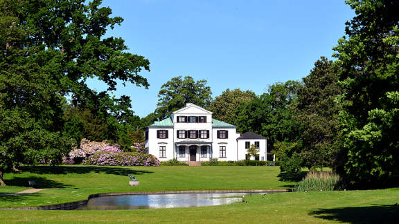
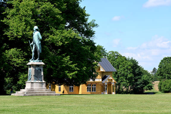
Bernstorff Slot:
Our route is basically straight ahead but to get there dog-leg first left then right, onto Skovvej and left again onto Fortunvej (GPS 55.76716 12.54600). Continue south-east of Fortunvej (left at the junction with Solbakkevej) for 1km to the junction with Slotsvej (GPS 55.76051 12.55639). Turn right onto Slotsvej and where it meets the main road (Jægersborg Alle) cross the dual carriageway to enter the grounds of Bernstorff Slot through the gated entrance ahead (GPS 55.75924 12.55523).
![]() 8
The palace and gardens were established in the mid-18th century, firstly for
Johann Bernstorff, the Danish foreign minister, and later as a royal summer
residence. Today it serves as a hotel and conference center.
8
The palace and gardens were established in the mid-18th century, firstly for
Johann Bernstorff, the Danish foreign minister, and later as a royal summer
residence. Today it serves as a hotel and conference center.
Continue up the avenue to approach the formal north entrance of the palace. To the right behind some trees is the timbered Swedish villa built for a Nordic exhibition in the late 19th century.
Straight ahead the driveway enters some trees, curves and dips to a six-way junction. Take the broader second junction on the right, uphill to emerge from the park onto Vældegårdsvej (GPS 55.75900 12.54454). Turn right and ascending slightly bend left to meet the five-way roundabout (GPS 55.76108 12.54360). Proceed anti-clockwise around the roundabout to take the fourth exit down Søndersøvej passing by Jægersborg church.
Gentofte:
Breeze down Søndersøvej to the major junction with Ermelundsvej (GPS 55.75910 12.53647). Turn left here heading south on Ermelundsvej. Pass under the road and railway bridges to the traffic lights at the junction with Brogårdsvej (GPS 55.75415 12.53416).
![]() 9
Straight ahead, through a green corridor, can be seen Gentofte Lake.
Go straight across the traffic lights onto the gravel track leading to
the lake. Now you can choose which side of the lake to cycle down.
Straight ahead is the slightly wilder west-side bordering the marshland,
and to the left is the more well-heeled east-side where Gentofte runs
down to the water.
9
Straight ahead, through a green corridor, can be seen Gentofte Lake.
Go straight across the traffic lights onto the gravel track leading to
the lake. Now you can choose which side of the lake to cycle down.
Straight ahead is the slightly wilder west-side bordering the marshland,
and to the left is the more well-heeled east-side where Gentofte runs
down to the water.
Either way the lake has surprisingly diverse bird-life for an urban lake, with many species nesting in springtime - among the more common are geese, grebes, coots, ducks and lapwings. Continue to the far south-end of the lake to where a gravel track leads up between bushes and trees (Søslippen) (GPS 55.74347 12.53718).
Where the gravel track meets the road turn right onto Søgårdsvej and left onto Anemonevej (GPS 55.74263 12.53694). Go straight across the junction with Gentoftegade and take the next right onto Begoniavej (GPS 55.74162 12.54303).
Proceed down Begoniavej until the junction with the larger Kildegårdsvej (GPS 55.73790 12.54312). Turn left onto Kildegårdsvej passing Gentofte hospital to the complicated junction with Niels Andersens Vej. Go striaght across the traffic lights to continue down Kildegårdsvej for another 100m or so to the junction with Eggersvej, which is camouflaged behind a tree (GPS 55.73587 12.55224). Zig-zag through the chicanes of Eggersvej and where it meets Hans Jensens Vej turn left (GPS 55.73273 12.55260). Go straight over the junction with Bernstorffsvej onto C V E Knuths Vej.
![]() 10
Cruise down C V E Knuths Vej passing the peaceful expanse of Hellerup
cemetery on your right.
At the crossroads with Rygårds Alle turn left
and then right at the traffic lights onto Hellerupvej.
Head down the cutting to pass under the railway on a narrow cycle path
and at the next set of traffic lights turn right onto Ryvangs Allé
(GPS 55.73233 12.56794).
10
Cruise down C V E Knuths Vej passing the peaceful expanse of Hellerup
cemetery on your right.
At the crossroads with Rygårds Alle turn left
and then right at the traffic lights onto Hellerupvej.
Head down the cutting to pass under the railway on a narrow cycle path
and at the next set of traffic lights turn right onto Ryvangs Allé
(GPS 55.73233 12.56794).
We have arrived at Hellerup train station. If you wish you can quit the tour here and hop on an S-train (A or C lines) to take you back to the centre of Copenhagen. Otherwise pass in front of the station and turn right at the traffic lights to continue down Ryvangs Allé, parallel to the railway tracks.
To the left are many fine houses, with a number of them taken by various embassies from countries around the world. Ryvangs Allé ends where it meets the extension of Østerbrogade heading north. Turn right at this junction to cross the railway (GPS 55.71663 12.57730).
Proceed down the wide Østerbrogade, heading south, to pass Trianglen (GPS 55.69939 12.57779), and the lakes. At the end of the lake continue onto Dag Hammarskjölds Allé to reach our starting point on Oslo Plads opposite Østerport station (GPS 55.69204 12.58706).
Notes on Knud Rasmussen:
Knud Rasmussen (1879-1933) was born in, what is now, Ilulissat in Greenland. He grew up with the locals and learnt their language and lifestyle. Later he was schooled in Denmark.
After an expedition in 1902 to examine the Inuit culture, he established a trading base in north-west Greenland at Thule. From there he set out on six great expeditions charting the geography and ethnography of the arctic region from Greenland across northern Canada to Alaska, by dog sled.
He died of pneumonia in Gentofte Hospital in 1933.