Enough of Hygge - 13 - Kalkmalerier and the western outskirts

Medieval church paintings.
Kong Svends Høj round barrow.
Viking bridge and Kroppedal museum.

Introduction
As well as bronze-age barrows Denmark boasts another historical treasure in its medieval church paintings (Kalkmalerier). Some of the best are mini-Sistine chapels in their coverage and story telling. The idea of this tour is to visit the best examples in the vicinity of Copenhagen (Ballerup, Måløv, Smørum and Vallensbæk). However this is somewhat hampered by the difficulty in gaining access to Ballerup and Smørum churches. However Måløv church is open daily and is nationally important, as well as being a beauty.
Even if you are not interested in churches and medieval paintings this tour is a splendid way to explore the expansive countryside midway between Copenhagen and Roskilde Fjord. The tour visits the first 3 previously mentioned churches and the bronze age burial mound of Kong Svends Høj, then heads south, across rolling landscapes to a reconstructed viking bridge and the Kroppedal museum, past Vallensbæk Church and ending at the S-tog station at Vallensbæk.
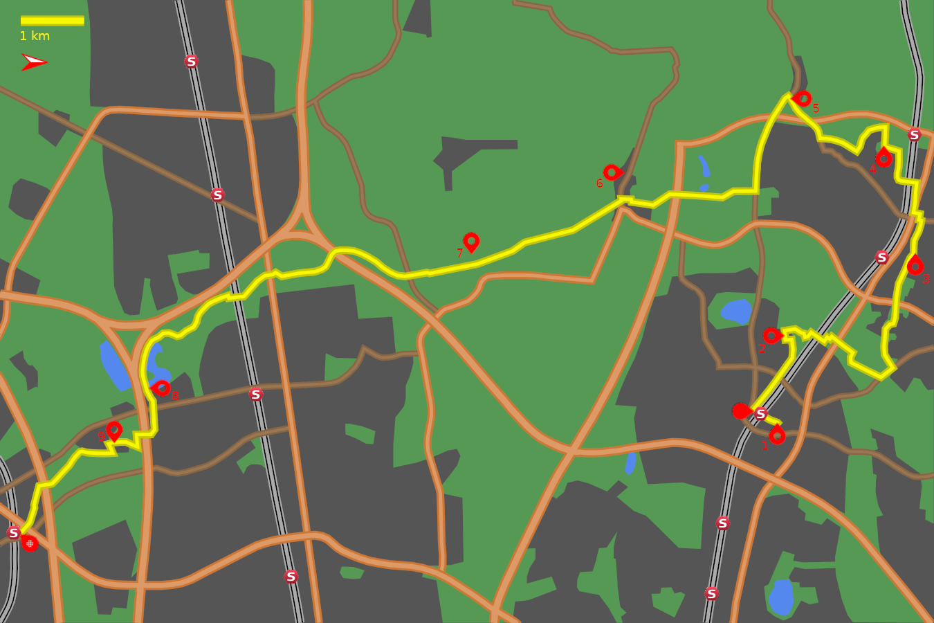
Note: The map (above) and photographs can be enlarged by clicking on them (opens in a new browser tab). On the map north is 90° clockwise, i.e. at 03:00 on an old school analogue clock.
![]() tart:
tart:
We will start at Ballerup Station (S-train C line) on the northern side of the station by the bus terminus. (GPS 55.73007 12.35815).
![]() In front of the station go round the bus terminal to the far side and leave
by its northern corner curving round onto Bydammen. Continue on this road,
across the traffic lights, and 200m further on the red-brick tower of
Ballerup Church appears within its white-walled churchyard.
(GPS 55.73245 12.36063).
In front of the station go round the bus terminal to the far side and leave
by its northern corner curving round onto Bydammen. Continue on this road,
across the traffic lights, and 200m further on the red-brick tower of
Ballerup Church appears within its white-walled churchyard.
(GPS 55.73245 12.36063).
Ballerup Church:
![]() 1
Ballerup Church is only open for general viewing on a Wednesday between
3pm and 5pm, but has some fine examples of kalmalerier, so if it can be
fitted in it is a worthwhile objective.
1
Ballerup Church is only open for general viewing on a Wednesday between
3pm and 5pm, but has some fine examples of kalmalerier, so if it can be
fitted in it is a worthwhile objective.
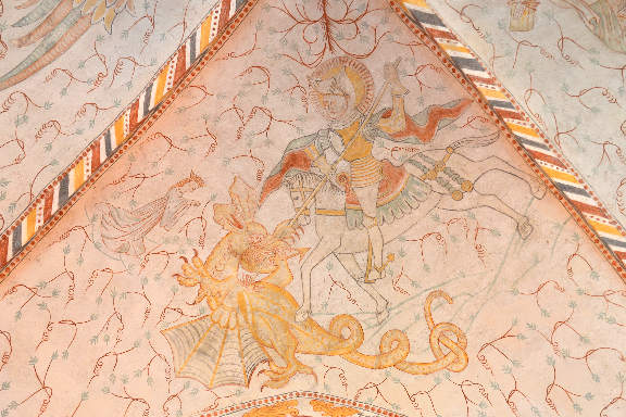
The initial stone church, comprising the nave and choir, was begun around the year 1200, and these can be picked out in the stone walls of the south face. The earliest painting (around 1240) can be seen up on the arch connecting nave and choir with images of Cain and Abel, Cain with his displeasing bunch of grain and the favoured Abel with his choice lamb.
The original flat wooden roof was replaced with a vaulted one around 1400, and shortly after the majority of the kalmalerier were completed. Although biblical figures dominate the scenes a depiction of St George and the Dragon is dazzling. A sense of fun can also be seen in the adjacent painting of St Michael weighing souls with two playful devils trying to pull the scales down.
To continue the tour return to the entrance of Ballerup train station (GPS 55.73007 12.35815). and use the subway, at the right-hand end of the station building, to go under the railway tracks to the south side. Immediately on exiting the subway is a cycle track. Take this, turning right, and continue, parallel to the railway tracks for 400m. At a left hand bend take the turning on the right signposted "Pederstrup" and "Kilderuten" (GPS 55.73230 12.35139).
Ballerup open-air museum:
![]() 2
The cycle track passes open fields
(GPS 55.73490 12.34268),
before coming to a cross-way at the edge of Ballerup museum
(GPS 55.73447 12.33926),
The museum is a collection of farm buildings and
town houses with exhibitions and events, plus entry is free. Take the
narrow track ahead between the buildings and turn right at the end to
pass the entrance to the museum
(GPS 55.73372 12.33907).
2
The cycle track passes open fields
(GPS 55.73490 12.34268),
before coming to a cross-way at the edge of Ballerup museum
(GPS 55.73447 12.33926),
The museum is a collection of farm buildings and
town houses with exhibitions and events, plus entry is free. Take the
narrow track ahead between the buildings and turn right at the end to
pass the entrance to the museum
(GPS 55.73372 12.33907).
At the road junction, 100m further on, turn right. (GPS 55.73372 12.33650). The road winds past a farm heading back towards the railway tracks. Just before the railway the track veers left (GPS 55.73706 12.33916). which takes you through a tunnel. Take the ramp on the left up onto Lindbjergvej (GPS 55.73852 12.33800). Go straight over the road onto the gravel track heading into the woods. Weave right then left, then turn left at the next junction, onto tarmac, to curve round to a subway under the main road (GPS 55.74086 12.33922). Emerging from the subway turn left onto the gravel track and where the track splits next to a lily-pond take the right branch (GPS 55.74290 12.34204). This track joins a gravel road (Brandmosevej), turn left going uphill (GPS 55.74247 12.34370), and fork left in front of the white house (GPS 55.74270 12.34520).
The gravel road passes fields and woods before dropping down to a tarmac road (Jonstrupvej) (GPS 55.74732 12.34831). Turn left onto this and continue for 200m to the junction with Fuglehavevej (GPS 55.74877 12.34638). Turn left here to join cycle route 69 on a gravel track which crosses Østerhøj Nature Park. Continue straight ahead at every junction, veering left where it meets buildings at Møllemosen (GPS 55.74896 12.33538), and continuing to a subway under a road.
Måløv Church:
This track continues through the park and sports ground to a dramatic reveal of Måløv Church at Kratvej (GPS 55.75174 12.31723).
![]() 3
Måløv Church occupies a knoll in a shallow valley.
Small but beautifully kept, it was raised around 1150 (nave and choir)
and most of the surviving wall paintings date from that period. Notable are
the gold-painted stucco features emphasising the haloes and clothing.
The painting of the Madonna and Child in the niche shows Byzantine influences.
3
Måløv Church occupies a knoll in a shallow valley.
Small but beautifully kept, it was raised around 1150 (nave and choir)
and most of the surviving wall paintings date from that period. Notable are
the gold-painted stucco features emphasising the haloes and clothing.
The painting of the Madonna and Child in the niche shows Byzantine influences.
The tour continues with a left turn onto Kratvej which ascends gently to the junction with Måløv Hovedgade (GPS 55.75142 12.31477). Turn right and climb higher to the junction with Jungshøjvej (GPS 55.75272 12.30897). Turn left and proceed to the major junction with Måløv Byvej (GPS 55.75116 12.30861). Do not cross the lights but take the track immediately on your right that spirals down to a subway beneath the road.
Emerging from the subway turn to the right to run parallel to the railway (GPS 55.75071 12.30749). A set of steps leads up to a road (Måløv Værkstedsby). Continue past the offices to the next crossroads (GPS 55.75165 12.29917).
Kong Svends Høj:
Turn left at the crossroads (Kongebakken) passing over the railway and follow the road round to the right (GPS 55.74951 12.29831), and keep going to the end (GPS 55.74968 12.29138). Where the road ends take the cycle track on the left that leads up to Kong Svends Høj (GPS 55.74739 12.29014).
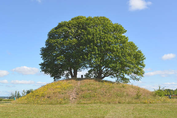
![]() 4
Kong Svends Høj is crowned with a couple of majestic
(oak) trees. The bronze-age mound has never been excavated, so no one knows
its exact age, or if a king is actually buried there, let alone if he is
called Svend. The view west is commanding, the valleys lead down to Roskilde
Fjord.
4
Kong Svends Høj is crowned with a couple of majestic
(oak) trees. The bronze-age mound has never been excavated, so no one knows
its exact age, or if a king is actually buried there, let alone if he is
called Svend. The view west is commanding, the valleys lead down to Roskilde
Fjord.
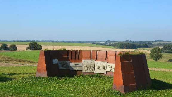
Leave Kong Svends Høj heading west, immediately to the right of the housing estate. Where this track turns left is a monument (Panoptikon) (GPS 55.74770 12.28548) depicting some of the prehistoric finds from the area. Continue south, keeping the open fields on your right, until you come to a junction with another track heading downhill, to the right (GPS 55.74342 12.29186). Head downhill, crossing the road (Kong Svends Vej), and up the other side to where the track meets another road (Kirkevangen) (GPS 55.73836 12.28782).
Smørum Church:
Turn right onto this road (kirkevangen) and continue until the red bricked Smørum Church appears on the left (GPS 55.73480 12.27950).
![]() 5
Smørum Church displays an assortment of styles,
from different ages, on its exterior. Access to the interior can be a matter
of luck as the church is normally only open for services. But if you are lucky
then you may find some of the typically irreverent medieval subjects of the
wall paintings intriguing, such as
5
Smørum Church displays an assortment of styles,
from different ages, on its exterior. Access to the interior can be a matter
of luck as the church is normally only open for services. But if you are lucky
then you may find some of the typically irreverent medieval subjects of the
wall paintings intriguing, such as a man eats his stomach
, or
a man pees into a bucket
, and more!
When suitably recovered, continue to the end of Kirkevangen and turn left at the junction onto Skebjergvej (GPS 55.73444 12.27708). After 1km go straight over the traffic lights (GPS 55.72986 12.29080), then 700m further, where a large playing field appears on the left, there is a pedestrian/cycle crossing (GPS 55.72924 12.30136). Turn right onto the track heading south. A small sign indicates cycle route 69 and a heading towards Ishøj Strand.
Ledøje Church:
This quiet cycle track traverses a golf course, then a forest before diving under the Frederikssund motorway. Emerging on the other side you soon reach the outskirts of Ledøje. The track jinks right then left and crosses a narrow lane (Ledøje Nordre Gade) before meeting the main road through the village (Ledøje Bygade) (GPS 55.71013 12.30346).
![]() 6
The continuation of the cycle route is 20m to the left (east), but if
churches are your thing then Ledøje Church, 400m
to the west, is worth visiting for its unusual two storey construction.
This was presumably to allow the landed gentry to keep aloof from the
common people.
6
The continuation of the cycle route is 20m to the left (east), but if
churches are your thing then Ledøje Church, 400m
to the west, is worth visiting for its unusual two storey construction.
This was presumably to allow the landed gentry to keep aloof from the
common people.
Take the continuation of cycle route 69 (signposted Ishøj Strand), that runs between the houses, (GPS 55.71017 12.30382), which leads quickly into open countryside. Almost 2km further the track crosses a stream (Risby Å) and tarmac turns to gravel. Shortly after another track joins from the left (GPS 55.69424 12.31654). Keep going south (straight ahead).
Viking Bridge and Kroppedal Museum:
After another 650m the track meets a forest (GPS 55.68894 12.32003). The track to the left, through the forest leads to a reconstructed viking village (Vikingelandsbyen).
![]() 7
Conversely to the right is a reconstructed viking track and bridge crossing
the stream, with an example cross-section of the bridge standing in
the field to show the construction method.
7
Conversely to the right is a reconstructed viking track and bridge crossing
the stream, with an example cross-section of the bridge standing in
the field to show the construction method.
On the other side of the bridge, hidden behind trees, is the Kroppedal Museum. Amongst other things this celebrates the acheivment of astronomer Ole Rømer who proposed that light has a finite speed and measured the positions of Jupiter's moons to prove it.
If you are not tempted by any of these attractions then our route continues south, with the forest on the left, until you meet a road (Snubbekorsvej) (GPS 55.67983 12.32261). Cross the road and take the right hand track. After 300m the track forks by Albertslund golf course (GPS 55.67738 12.32261). Take the right hand branch which leads (after 1 km) to a subway under the motorway.
Soon you come to another fork (GPS 55.66840 12.31913), in the track, take the left fork, and then shortly after at another fork, go right. At the next crossing (GPS 55.66162 12.32306) go straight ahead which leads up to a bridge over Roskildevej. Continue straight on and after 600m jink left then right to enter a low tunnel which goes under the railway on a grating running above the stream.
Kongsholm Park:
Emerging from the tunnel, the cycle route 69 turns right here (GPS 55.65503 12.32924), and then immediately bends left past the playground with the bird sculpture and beneath some recently landscaped hills (GPS 55.65059 12.32947). Keep straight ahead at every junction as the track curves alongside the Vejla river to reach Tueholm Lake (GPS 55.64449 12.33799)
![]() 8
Keep the lake to the left until you reach the restaurant
at the south end of Tueholm Lake
(GPS 55.64273 12.35188).
If you are inclined to seek them out the park contains two of Thomas Dambo's
giants; figures made from recycled wood.
8
Keep the lake to the left until you reach the restaurant
at the south end of Tueholm Lake
(GPS 55.64273 12.35188).
If you are inclined to seek them out the park contains two of Thomas Dambo's
giants; figures made from recycled wood.
Vallensbæk Church:
Go past a barrier to the parking area and leave the park at Rendsagervej. Turn right and at the major junction with Vejlegårdsvej go straight ahead onto Vallensbækvej. After 400m a sign for a cycle track to Vallensbæk Strand appears on the right (GPS 55.64344 12.36239). Turn right onto this track and at the bottom of the ramp turn left.
After passing under a motorway and railway turn left at the junction (GPS 55.64150 12.36317). and at the top of the ramp turn right onto Kirkebakke Alle (signposted Vallensbæk Church) (GPS 55.64155 12.36640).
![]() 9
Heading south you come to the new circular Helligtrekongers Church on the
right and the traditional Vallensbæk Church on the
left
(GPS 55.63789 12.36509).
9
Heading south you come to the new circular Helligtrekongers Church on the
right and the traditional Vallensbæk Church on the
left
(GPS 55.63789 12.36509).
The oldest parts of the church (nave and choir) date from 1150-1200, while the kalkmalerier were added between 1460 and 1480. If you have seen the paintings in any of the other churches you will note a different style (artist). As usual the majority of the pictures depict episodes from the bible, although a more contemporary image of Saint Olaf aboard a ship, harrased by a mermaid and devil can be found. There is also an intriguing image of Jesus heading for the realm of the dead, apparently riding a skateboard.
Leaving the church, head south on Kirkebakke Alle to the junction with the road (Brøndbyvej) (GPS 55.63686 12.36560). Turn left and after 200m at the junction with Højrupgårdsvej take the cycle track on the right immediately after the road (GPS 55.63748 12.36790). This is cycle route 67 which leads directly to Vallensbæk train station.
Vallensbæk Station:
Stay on this cycle track as it bends left (GPS 55.63272 12.36750), passes a school, ducks beneath a road (GPS 55.63054 12.37199), and then dives under a motorway (GPS 55.62780 12.37555). Continue through a housing estate to a roundabout for cyklists and pedestrians (GPS 55.62615 12.38142). Go straight over this roundabout, through another housing estate to a ramp which leads up over two roads. A sharp right (GPS 55.62491 12.38700). is followed by the down ramp.
![]() The building on the left is the town-hall. Continue to its end and turn left
(GPS 55.62359 12.38634),
just before the railway, and go along
Vallensbæk Stationstorv and the paved area ahead
to the entrance of Vallensbæk Station (in the tunnel)
(GPS 55.62358 12.38817).
The S-tog A line (towards Hillerød) will take
you back to central Copenhagen.
The building on the left is the town-hall. Continue to its end and turn left
(GPS 55.62359 12.38634),
just before the railway, and go along
Vallensbæk Stationstorv and the paved area ahead
to the entrance of Vallensbæk Station (in the tunnel)
(GPS 55.62358 12.38817).
The S-tog A line (towards Hillerød) will take
you back to central Copenhagen.
Alternative Start:
An alternative start is to begin at Lyngby Station (S-train A line), visit Lyngby Church with its medieval wall paintings, follow cycle route 69, and join the route above at Måløv. However the signage on this part of route 69 is poor and it is easy to lose ones way amongst the forests west of Lyngby. A map is essential as is a good sense of direction. Also the tracks through the forest are mostly gravel.
Notes on church wall paintings - kalkmalerier:
Medieval wall paintings in Denmark are one of its national treasures as there
are more surviving in this little country than in any other. They were hidden
for centuries, following the reformation, under a layer of limewash (kalk) and
only revealed when this was removed over the last two centuries.
A comprehensive website can be found at
Kalkmalerier,dk
An old-school printed book (in Danish) is
Politikens Bog Om Danmarks Kalkmalerier
by Axel Bolvig.